


5000
BC

4500 BC
Ocean Diving Begins
Around this time, several coastal cultures like those in Greece and China begin diving into the sea to gather food and engage in commerce. Diving is possibly even used in warfare.
4000
BC

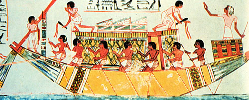
4000 BC
First Sailing Vessels
The ancient Egyptians develop the first sailing vessels. These vessels are probably only used for sailing in the eastern Mediterranean and near the mouth of the Nile river.
Wikipedia Public Domain Image
1000
BC

kallerna / CC BY-SA 3.0
1000 BC
Deep Diving Begins
The Greek poet Homer mentions sponge fishermen who dive as deep as 100 feet (30 meters) by holding on to a heavy rock. To compensate for the increasing pressure on their ears, they pour oil into their ear canals and take a mouthful of oil before diving. Once on the bottom, they spit out the oil, cut as many sponges free from the bottom as their breath will allow, and are pulled back to the surface by a tether.
600
BC
Elie plus at English Wikipedia /
CC BY-SA 3.0
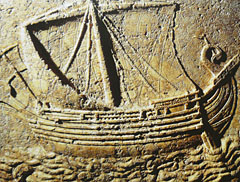
600 BC
First Sea Routes
In search of tin and other resources, the ancient Phoenicians develop sea routes around the Mediterranean and into the Red Sea and Indian Ocean. They make it as far as Africa by 590 B.C. They also reach England by sailing along the western European coast.
500
BC
Public Domain Image
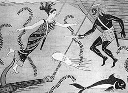
500 BC
Treasure Diving Begins
King Xerxes of Persia commissions a diver named Scyllias and his daughter Cyana to dive for treasure during one of the many wars between the Persians and the Greeks. When Xerxes refuses to let them return home, they use knives and snorkels to cut the ropes of the Persian fleet. Many of the drifting ships are damaged and sunk in the resulting collisions.
414 BC
Diving Used in Warfare
The Greek historian Thucydides writes about diving used in warfare in his narration of the siege of Syracuse. His writings tell of Greek divers who submerge to remove underwater obstacles from the harbor in order to ensure the safety of their ships.
400
BC
360 BC
First Crude Diving Bell Design
The Greek philosopher Aristotle mentions the use of a sort of crude, air-supply diving bell. Aristotle writes that "one can allow divers to breathe by lowering a bronze tank into the water. Naturally the container is not filled with water but air, which constantly assists the submerged man".
Wikipedia Public Domain Image
325 BC
First Use of a Diving Bell
Alexander the Great makes use of a crude diving bell to employ combat divers during the siege of Tyre. The diving bell contains colored glass so that the divers could see through it. The divers used the bell to clear debris from the harbor. Alexander himself makes several dives with the device to check on the progress of the work.
325 BC
Voyage of Pytheas
The Greek astronomer and geographer Pytheas sails north from the Mediterranean and reaches the coast of England. He is the first person on record to describe the midnight sun north of the Arctic Circle. He also develops methods for using the Sun and the North Star to determine latitude.
200
BC

NASA Public Domain Image
200 BC
Circumference of the Earth Discovered
The Greek astronomer Eratosthenes becomes the first person to determine the circumference of the Earth. He uses the angles of shadows and the distance between Alexandria and Syene to arrive at a value of 24,855 miles (40,000 kilometers). The actual circumference of the Earth is 24,874 miles (40,032 kilometers).
Wikipedia Public Domain Image
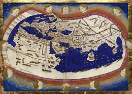
150 BC.
Ptolemy's Map
The Greek astronomer and geographer Ptolemy produces a map of the ancient world that includes the continents of Europe, Asia, and Africa as well as the surrounding oceans. This early map is one of the first known to include lines of latitude and longitude. Unfortunately this map would be lost to history but would be rediscovered in the years to come.
100
BC
100 BC
Salvage Diving Flourishes
Salvage diving operations around the major shipping ports of the eastern Mediterranean are so well organized that a payment scale is established by law for salvage work. This pay scale acknowledges the fact that effort and risk increase with the depth of the dive.