


1970

February 17, 1977
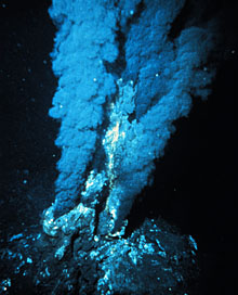
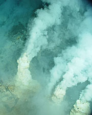
Hydrothermal Vents Discovered
Scientists aboard the deep sea submersible, Alvin, discover and document incredible deep sea hydrothermal vents in the eastern Pacific ocean. Scalding hot water pouring from these vents enriches the water with nutrients and provides food for bacteria and a host of other organisms. This discovery rocks the scientific community because, for the first time, an ecosystem has been found that thrives without the energy of the Sun. Instead of relying on sunlight and photosynthesis, these ecosystems thrive on chemical energy through a process known as chemosynthesis.
NOAA Public Domain Image
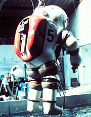
September 19, 1979
Deepest Dive in Dive Suit
Doctor Sylvia Earle sets a new record for a deep dive in a dive suit. Using a new pressurized metal suit known as a JIM suit, she walks unassisted at a depth of 1,250 feet (381 meters). Dr. Earle explores the depths off the coast of Oahu, Hawaii for two and a half hours with only a communication line connecting her to a submersible, and nothing connecting her to the world above.
1980

Edward L. Perry IV / CC0
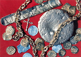
July 20, 1985
Atocha Found
Famed treasure hunter Mel Fisher finds the wreck of the Atocha off the coast of the Florida Keys. Lying in only 55 feet (17 meters) of water, the Atocha would soon yield the biggest treasure ever recovered from a shipwreck. The discovery would come at a price, however. Mel loses his son, Dirk, Dirk's wife, and another crewmember in a tragic boating accident in 1975 while searching for the wreck of the Atocha.
NOAA Public Domain Image
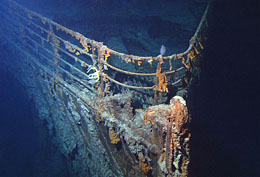
September 1, 1985
Titanic Found
Dr. Robert Ballard, with the help of a tiny robotic submarine named Jason, discovers the wreck of the Titanic. The wreck is found in 12,500 feet (3,810 meters) of water about 375 miles (604 kilometers) off the coast of Newfoundland in Canada. The wreck of the Titanic is found in two separate pieces, dashing any hopes of one day raising the mighty ship.
1990
1990
Argo Project Begins
A program known as Argo begins to deploy 3,000 robotic probes throughout the world's oceans to monitor climate, weather, and sea surface height. It is named after the mythical ship from the story of Jason and the Argonauts. The last probes are successfully placed in 2007.
NASA Public Domain Image
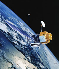
August 10, 1992
Ocean Surface Mapping
The TOPEX/Poseidon satellite is launched, providing oceanographic data that was previously impossible to obtain. It is a joint satellite mission between NASA and CNES to map ocean surface topography. From orbit 826 miles (1,330 kilometers) above Earth, TOPEX/Poseidon provides measurements of the surface height of nearly 95 percent of the ocean to an accuracy of 1.3 inches (3.3 centimeters). The satellite's measurements of the hills and valleys of the sea surface lead to a new understanding of ocean circulation and its effect on climate.
NASA Public Domain Image
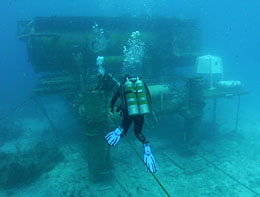
1993
Undersea Laboratory Aquarius
An undersea habitat known as Aquarius begins operation in the U.S. Virgin Islands. It is later moved to its current location, 3.5 miles (5.6 kilometers) off the coast of Key Largo in the Florida Keys National Marine Sanctuary. Aquarius resembles an underwater apartment and lab that can accommodate six-person teams during 10-day missions. Scientists live, eat and sleep in the habitat and work outside for six to nine hours each day. Aquarius operates until 1996 and helps revolutionize the study of coral reefs.
Wikipedia Public Domain Image
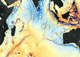
1995
Seafloor Mapping from Space
Declassification of Geosat satellite radar altimetry data leads to worldwide mapping of the sea floor from space. Launched in 1985 by the U.S. Navy, Geosat measures the height of the sea surface by bouncing a radar beam off it. In 1995, the Navy finally declassifies the Geosat data. David Sandwell of the Scripps Institution of Oceanography and Walter Smith of the National Oceanic and Atmospheric Administration are able to use this data to make detailed maps of the ocean floor. Their observed data significantly enhances accuracy over earlier images of the ocean basin.
2000
StifynTonna / CC BY-SA 3.0
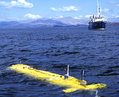
2000
Autosub is Launched
The Southampton Oceanography Centre (SOC) develops and launches an automated robotic vehicle to study the oceans. Known as autosub, the autonomous submersible is equipped with an array of scientific sensors and is capable of carrying out pre-programmed missions. Because the vehicle is completely self-contained, it is capable of traveling to regions of the ocean that were previously inaccessible.
StifynTonna / CC BY-SA 3.0
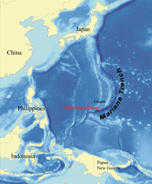
January 6, 2009
Mariana Trench National Monument
President George W. Bush established the Mariana Trench National Monument. The monument contains no dry land but protects 95,216 square miles of ocean in the Mariana Archipelago. This area contains rare hydrothermal vents as well as some of the few places in the world where chemosynthetic communities of life have been discovered.
2010
NOAA Public Domain Image
2010
Census of Marine Life Completed
The first ever global census of marine life is completed. This 10 year project involves 2,700 scientists from 80 nations. The census reveals what, where, and how much lives and hides in global oceans and is made available in an online directory that allows anyone to map global addresses of species.
NOAA Public Domain Image
July 2011
Mariana Trench Expedition
An expedition crew returns to the Mariana Trench using modern submersibles. Among the new discoveries is a single-celled amoeba that measures an incredible 4 inches in diameter. Scientists also learn that trenches play a larger role in regulating the Earth's chemistry and climate than was previously thought.
2012
Portable Underwater Habitat Developed
National Geographic Society/Waitt grantee Michael Lombardi develops a portable underwater habitat that can assist divers with decompression. It provides divers with a comfortable environment to decompress as they return to the surface from deep dives. This new habitat can enable extended dives on deep coral reefs with minimal cost and infrastructure.
Angela George / CC BY-SA 3.0
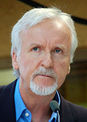
March 25, 2012
First Solo Dive to the Mariana Trench
Hollywood director James Cameron becomes the first person to perform a solo dive to the bottom of the Mariana Trench, the deepest point in the ocean. Cameron dives nearly seven miles and reaches a depth of 35,756 feet (10,898 meters). He spends three hours filming on the bottom of the trench before returning to the surface.
July 2012
First Video of Giant Squid
A Japanese expedition and film crew captures the first video of a live giant squid in its natural environment. This elusive creature has previously only been seen when dead specimens wash ashore or are caught in fishing nets. The squid captured in the video measures only 9 feet (3 meters) in length, which is relatively small. Giant squid can grow to over 60 feet (18 meters) in length.
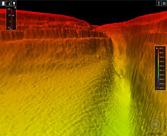
Photo: Royal Navy/MOD / OGL v1.0
2017
Seabed 2030 Announced
A major new international inniative to map the ocean floor is announced. Seabed 2030 is a collaborative project between the Nippon Foundation of Japan and the General Bathymetric Chart of the Oceans (GEBCO). It aims to bring together all available bathymetric data to produce a definitive map of the world ocean floor by 2030. The project will use over a dozen tracking ships outfitted with advanced multibeam bathymetry technology and will hwlp fill in the gaps in our knowledge of the ocean floor, of which less than 15 percent has been mapped in detail.